When Farmland Becomes the Front Line, Satellite Data and Analysis Can Fight Hunger
It is difficult to predict exactly how events like extreme weather, pandemics, conflict, and politics will disrupt global food systems and cause people to go hungry. The destabilizing impacts of the COVID-19 pandemic (inflation, employment crises, supply chain disruptions, higher prices for fertilizer and fuel), exacerbated by climate disruptions and war, has led 200 million more people to experience higher levels of food insecurity than prepandemic levels. Today, 1 in 10 people around the world are food insecure, but forecasting how global events will affect insecurity remains a challenge.
Timely, transparent, actionable crop production data aggregated from local to global levels is necessary to inform farmers, policymakers, and humanitarian organizations making decisions about food production and distribution. Most countries publish crop information that has been collected through ground-based surveys of farmers’ production levels, acreage, and yields. Governments and international organizations also track supply chain disruptions, trade flows, food stocks, and market data on consumption. These data are then used to anticipate how supply and demand will affect prices and, by extension, food insecurity and social unrest.
Today, 1 in 10 people around the world are food insecure, but forecasting how global events will affect insecurity remains a challenge.
When a shock to the global food system occurs—such as during the Russian invasion of Ukraine in 2022—collecting the usual ground-based data is all but impossible. The Russia–Ukraine war has turned farmland into the front lines of a war zone. In this situation, it is unreasonable to expect civilians to walk onto fields riddled with land mines and damaged by craters to collect information on what has been planted, where it was planted, and if it could be harvested. The inherent danger of ground-based data collection, especially in occupied territories of the conflict, has demanded a different way to assess planted and harvested areas and forecast crop production.
Satellite-based information can provide this evidence quickly and reliably. At NASA Harvest, NASA’s Global Food Security and Agriculture Consortium, one of our main aims is to use satellite-based information to fill gaps in the agriculture information ecosystem. Since the start of the Russia–Ukraine conflict, we have been using satellite imagery to estimate the impact of the war on Ukraine’s agricultural lands at the request of the Ministry of Agrarian Policy and Food of Ukraine. Our work demonstrates how effective this approach can be for delivering critical and timely insights for decisionmakers.
Prior to the war, Ukraine accounted for over 10% of the world’s wheat, corn, and barley trade and was the number one sunflower oil exporter, accounting for close to 50% of the global market. In other words, food produced in Ukraine is critical for its national economy, for global trade, and for feeding millions across the globe. As such, it was immediately important to have an accurate perception of how the war was impacting agricultural production. How much cropland was being abandoned due to Russian occupation or proximity to active fighting? How much cropland had been damaged by artillery craters? How would land losses impact future crop yields? How was planting and harvesting on unoccupied land progressing? Satellite data collected from multiple sources, including Planet Labs (a satellite imaging company), NASA, and the European Space Agency, provided the only means to answer these questions quickly.
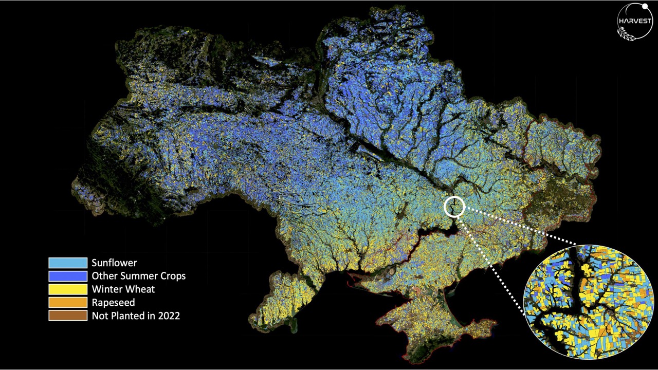
Ukrainian Crop Types
CROPLAND DAMAGED BY WAR
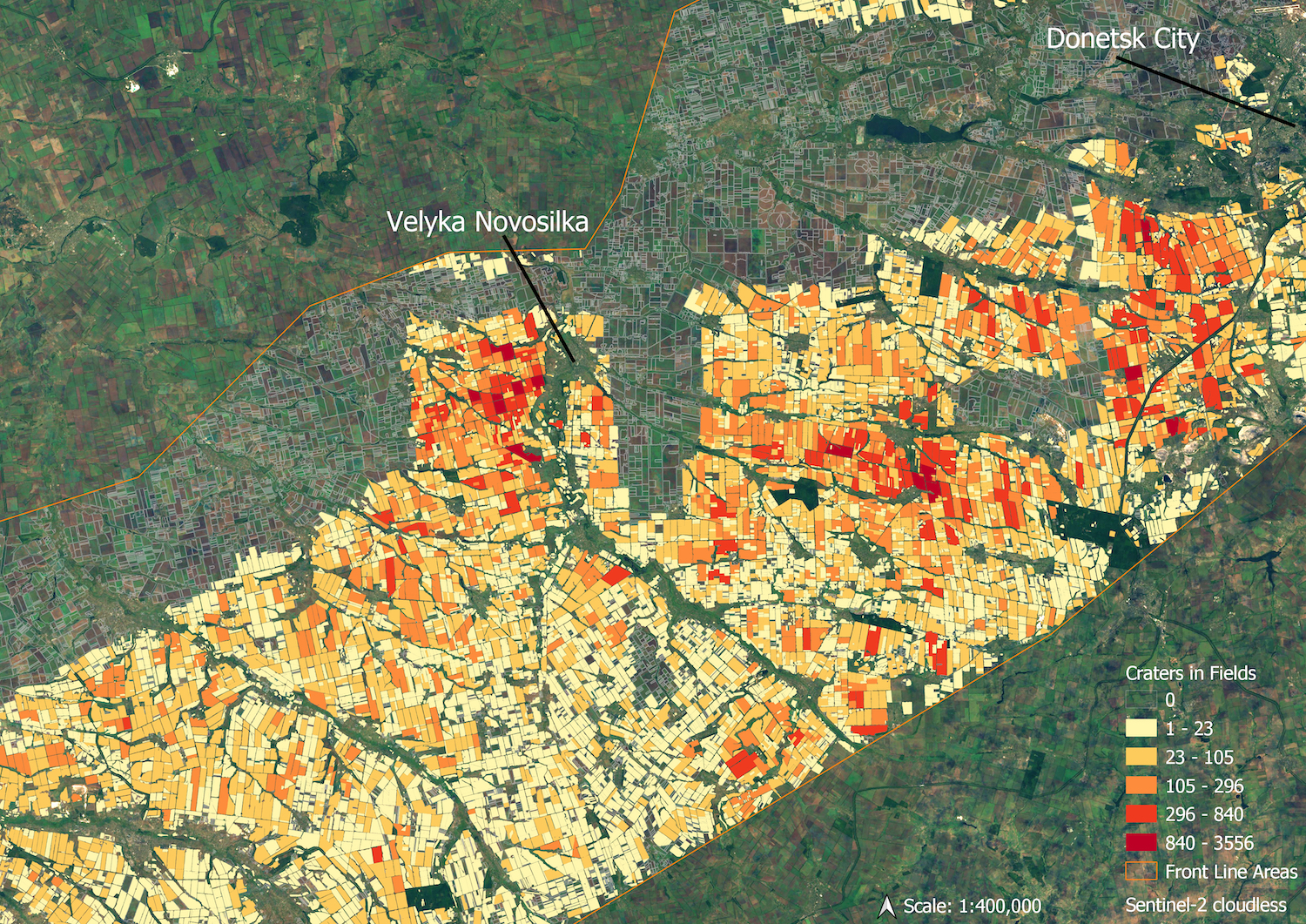
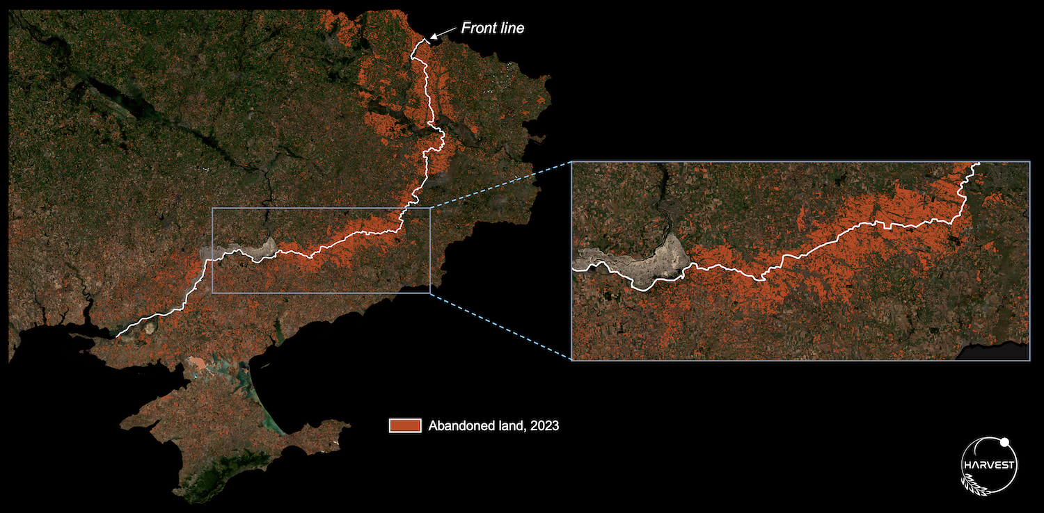
Our analysis found that Russia occupied approximately 22% of Ukraine’s cropland. While many observers speculated that in 2022 production would be significantly reduced—with the winter crop harvest (mainly wheat and barley) and the spring crop planting (largely corn and sunflower) 30% to 50% lower than previous years—the satellite data revealed a different story. We found that close to 90% of the wheat crop had been harvested, and that the large majority of available croplands were planted with spring crops. Planting and harvesting losses were concentrated along the front line. We estimate the amount of abandoned cropland in Ukraine in 2023 is equivalent to about 7.5% of total cropland in the country. Still, that’s a lot of land; had this land been planted, it could have produced enough to feed 25 million people for one year.
In 2022, production of staple crops in Ukraine was only slightly below the five-year average and in 2023 it was close to or slightly above average (depending on the crop), largely owing to good yields. Crucially, however, a large proportion of this production—approximately 22% of wheat and 10% of sunflower—was harvested in the Russian-occupied territories. To put this in perspective, the wheat harvested in the occupied territories in 2023 is roughly equivalent to the 2023 wheat harvest of Kansas (the second-largest producing state in the United States) and represents about 60% of total wheat imports to Egypt (the world’s largest wheat importer). To date, NASA Harvest is the only entity reporting on the production of crops in the occupied territories, which are continuing to produce a sizable amount of staple crops critical for global food supplies.
Our work in Ukraine underscores the potential for satellite data and analysis to fill serious gaps in agricultural information during food system shocks and when ground access is disrupted.
Taras Vysotskyi, first deputy minister of Agrarian Policy and Food of Ukraine, noted that NASA Harvest’s assessment has helped his government understand the real state of agricultural production in Ukraine, evaluate how best to ensure regional food security, and determine export levels to support global food security.
Indeed, information about food production is its own kind of currency. “Assessing the global supply situation and being able to predict unexpected shortfalls is a critical task to guarantee global food security,” according to Abdolreza Abbassian, former secretary of the Agricultural Market Information System (AMIS) and senior economist at the Food and Agriculture Organization of the United Nations. Reliable data about agricultural commodities can enable governments and other organizations to buffer global price volatility and ensure well-functioning markets and trade relationships that are critical for ensuring food security and access, particularly in the world’s poorest regions and in countries dependent on food imports. Quantifiable, science-based information on crop production and potential shortfalls can inform policy decisions on trade, infrastructure, agricultural investments, and farmer safety-net programs—and, most directly, which crops to plant when and where. These insights can be used to shape markets and steer humanitarian relief to help prevent suffering and political upheaval.
ABANDONED CROPLAND ON THE FRONT LINES
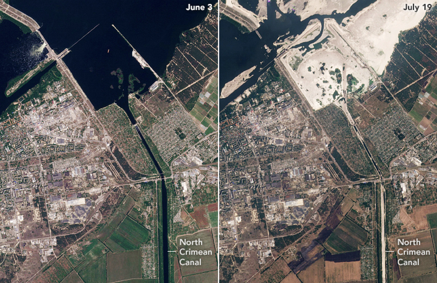
IRRIGATION SYSTEMS BEFORE AND AFTER THE KAKHOVKA DAM COLLAPSE
Our work in Ukraine underscores the potential for satellite data and analysis to fill serious gaps in agricultural information during food system shocks and when ground access is disrupted. In our experience, despite a large and growing demand for such analysis, there is a notable deficit in institutional capacity to deliver the kinds of rapid, satellite-driven assessments necessary to guide policy and humanitarian decisions. Many national and international organizations use remote sensing technologies for agricultural assessments, but a dedicated, state-of-the-art agricultural analysis facility does not exist. The need for such standing capacity has been recognized by multiple US government agencies, as well as by other national governments, United Nations organizations, humanitarian organizations, and policy frameworks such as AMIS. The demand for such analyses is currently unmet.
We propose establishing a dedicated facility that can be activated whenever events threaten agricultural production, distribution, or information transparency. The facility should focus on rapid, satellite-driven agricultural assessment in support of decisionmaking. It should be connected to ongoing efforts in this space, including the Group on Earth Observations Global Agricultural Monitoring (or GEOGLAM) initiative, an open community that leverages international agricultural remote sensing capacity developed across the globe. And it should be a hub where stakeholders, including national government and humanitarian agencies, can guide analysis requests.
We propose establishing a dedicated facility that can be activated whenever events threaten agricultural production, distribution, or information transparency. The facility should focus on rapid, satellite-driven agricultural assessment in support of decisionmaking.
Today, capacity to provide information and analysis with each new crisis grows and shrinks, depending on the resources allocated to the response. A standing facility would create more stable capacity to leverage the full suite of satellite, ground, and socioeconomic data; cloud computing and machine learning models; domain expertise; and a network of diverse partners to quickly and accurately prepare assessments for crises that affect agriculture. This would allow for actionable science-driven information to be produced in a timely fashion in response to political, economic, and humanitarian needs and end-user requirements.
The facility’s focus would be on analyzing three primary types of food system shocks: armed conflict and war; extreme weather events, such as drought and floods or natural disasters; and regions with high agricultural uncertainty or low data transparency. The facility would build a sustainable system prepared to fill key agricultural information gaps. In addition to producing rapid agricultural assessments in response to requests, the center would simultaneously develop methodologies that could be shared with the international community to build further capacity for agricultural monitoring and decisionmaking.
As disruptions from severe climate-related events and armed conflicts are projected to increase and as agricultural market transparency in critical producer countries declines, rapid satellite-based assessment will become ever more vital. NASA Harvest has recently received requests for assessments on the food emergency impacts of the conflicts in the Democratic Republic of the Congo and in Ethiopia’s Tigray region; the effects of late rains over wheat-growing regions in China; the outcomes of efforts to map Togo’s smallholder croplands in support of the government’s aid programs to its smallholder farmers during COVID 19; and the enduring consequences of the 2022 floods in Pakistan. We can certainly expect, and must plan to meet, an increasing demand for food-related information on our rapidly changing planet.
Attaining global food security is necessary for a healthier, more prosperous, and more equitable world. Preventing or efficiently managing food system disruptions requires timely and reliable information. With a rigorous, sustainable approach to data collection and analysis, satellite data can improve our understanding of global food systems and prepare society to respond to the next crisis.